Valuation of Peatlands as CO₂ Stores

Developing AI-Based Monitoring Tools to Promote Sustainable Land Use

VALPEATS — Valuation of Peatland Ecosystem Services

VALPEATS combines available input variables (such as map data, scientific studies and meteorological data) with field observations (including drone imagery and water level data) and classifies them using AI. This then allows for polygonal partitioning of water levels and vegetation (vegetation units or indicator species, for example) over unknown areas, making it possible to regularly monitor the condition of specific peatland areas and providing the necessary input data for CO₂ certificates and smart farming, for example.

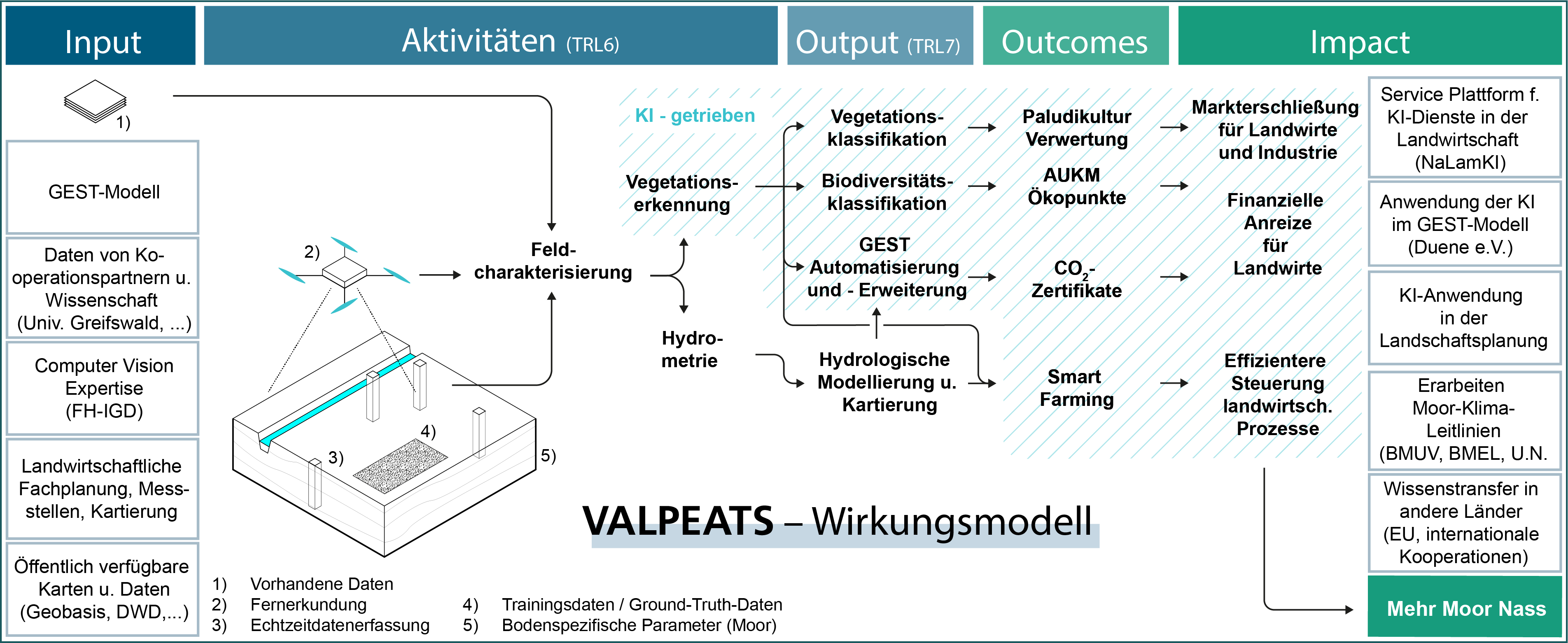
The GEST model (Couwenberg et al., 2008, 2011; Joosten et al., 2013) is (frequently) used to quantify the climate impact of peatlands. GESTs (Greenhouse Gas Emission Site Types) are defined as homogeneous in terms of their greenhouse gas (GHG) emissions and  are characterized by typical vegetation types. The vegetation serves as a proxy for estimating water levels in the peatlands. Since this is the main driver of emissions, it can be used as an estimate of the amount of carbon dioxide (CO₂) being emitted. Time, required staff (with specialized botanical training), geographic transitions (blurring), and limited scalability are the challenges in identifying GESTs. We expect a digitized solution for identifying vegetation to deliver:

  • Rigorous monitoring to quantify emission reductions
  • Increased accuracy in identifying vegetation
  • Improved scalability (more area output with the same staffing and cost)
  • Ability to employ staff without botanical expertise
  • Continuous monitoring quality

In the case of financial products aimed at reducing greenhouse gas emissions (CO₂ certificates) or improving biodiversity (AUKM, ecopoints, CSRD, etc.), these points will make it possible to provide a monitoring system that allows for transparent and verifiable reporting of relevant changes in the monitored ecosystem. An automated, digital monitoring solution also promises to monitor the planned additional 50,000 hectares of rewetted peatland each year.

Data cubes (3D tensors) and metadata are the input for the AI models. The x and y axes of the data cube correspond to the geocoordinates. The z axis shows the spectral bands of the camera sensors as well as calculated values, such as the digital surface model value or the NDVI vegetation index. Metadata, such as the date, contains important information for evaluating the data cube, including the phenological stage of the plants.

Water Level Monitoring and Hydrological Modeling

In addition to vegetation mapping, direct determination of water levels in peatlands is becoming increasingly relevant. The increasing frequency of extreme weather events such as droughts and heavy rainfall, as well as the increasing degradation of peatland soils due to progressive deep drainage, impact the correlation between vegetation and water levels, making it difficult to derive greenhouse gas fluxes using GEST. Against this background, a multisensory approach is being developed to instrument the areas and derive hydrological information (including modeling) in the peatlands. This information will be combined with the GEST model.

Cross-method technologies are being developed in the following areas:

  • Drones equipped with multispectral cameras are capturing high-resolution image data of peatlands.
  • Deep learning models are being trained to recognize vegetation types based on their spectral signature and shape/texture. For this purpose,
  • training data sets (ground truth data) are being generated in the field by botanical mapping using RTK-GNSS.
  • In addition to aerial images, digital surface models and calculated indices such as NDVI are improving the classification.
  • In situ sensor technology is recording water levels in the peatlands (groundwater table distance). This sensor technology is connected to gateways that ensure automated data transmission.
  • The water table depth is being modeled by hydrological modeling with the use of additional boundary conditions.
  • An online platform has been created to connect the data stream and to implement the algorithms to be developed for evaluating the input data. A user-friendly graphical display of the data on a dashboard and in an API is also being developed.
How a dashboard display might look

Paludiculture

Around 25 years ago, the Greifswald Mire Centre coined the term paludiculture (from the Latin palus, meaning wet) as an umbrella term for a wide range of cultivation techniques that can be used on wet peatlands. Examples include the cultivation of cattail or reeds in fens as a raw material for insulation and building materials and the cultivation of peat mosses as a substitute for peat in substrate production.

Establishing paludiculture techniques, developing biomass value chains and valorizing peatland ecosystem services are considered key factors for accelerated rewetting.

The development of the “vegetation identification” and “water level monitoring and hydrological modeling” components gives rise to other potential applications that can support the establishment of paludiculture:

  • The majority of the paludiculture areas are being cultivated using a method known as aufwuchs paludiculture. (The German term Aufwuchs, meaning “surface growth,” refers to a mixture of plants and animals that accumulate on submerged surfaces.) Aufwuchs paludiculture denotes process by which other typical peatland plant populations are established solely by raising the water level, without the need to cultivate specific plants. Experience has shown that, especially in the first ten years, there is an emergence of heterogeneous biomass populations that are difficult to exploit. Classifying the vegetation helps to determine the quality and composition of the harvested bales. This information can be used, for example, to more efficiently control incineration in biomass cogeneration plants, or to decide whether a bale is more suitable for incineration, for use as animal feed, or for material recycling.
  • In both aufwuchs paludiculture and cultivation-based paludiculture, knowledge of vegetation growth and hydrology can be used to observe how biomass populations evolve and where specific adjustments need to be made to optimize yields.
  • The development of value chains is essential for establishing paludiculture. The processing industry uses information on the type and prevalence of paludiculture biomass as a basis for deciding where to locate their production facilities.

Further Information


To learn more about our Smart Farming research:


To learn more about our peatlands research: