Planning tools for fiber optic roll-out

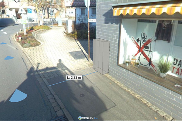
How Fibre3D makes fiber planning easier: In 3D, the exact position of the network distribution boxes can be determined, measured and attached to the permit application as a photo montage.

In its endeavors to provide Germany with high-speed broadband, Deutsche Telekom is rolling out fiber optics on a massive scale throughout the country. The laying of the glass fiber cable itself is actually one of the last steps in the complex roll-out process. It is preceded by extensive planning and by applications to public authorities and local communities that involve multiple coordination loops and on-site meetings. To accelerate these processes, Deutsche Telekom has been making use of automated procedures, in which specially equipped cameras and laser scanners generate input for digital maps, and an automatic object recognition system which suggests distribution box locations and route layouts that need only to be verified by planners.


Software-Demo and further details

Network distribution boxes: Virtual planning in 3D

Until now, however, there was always one small but crucial detail that could not be planned from a desk, but always required on-site inspections and measurements, namely where to position the network distribution boxes from which the individual fiber optic cables branch out to customers’ homes. The only viable method by which the planners could identify a suitable location was for them to make a time-consuming personal visit to the site. Our Fibre3D software package now provides an alternative solution in the form of an interactive 3D visualization of the target area based on panoramic images and point clouds. Fibre3D allows planners to immerse themselves in a three-dimensional world, to virtually position the boxes and thus find the most suitable location from the comfort of their office desk. Measurement functions and true-to-scale projections allow for a speedy inspection of even the most technically challenging locations. The integration of additional information such as the presence of underground pipes and cables facilitates the evaluation of different configurations. Once digital planning is complete, instructive photomontages can be generated directly from the tool for inclusion with the application documents to secure the site. This realistic impression also makes it easier to obtain approval from authorities responsible for maintaining the route.

Fibre3D has already been successfully deployed in practice, providing planning support for the positioning of distribution boxes. This software solution shows convincingly that a complete digitization of the planning, verification and approval processes can significantly accelerate the expansion process. The next stage of roll-out will see performance optimizations being made and the use of the software by external partners of Deutsche Telekom.
Organization of data evaluation in a cloud-based infrastructure

The automated planning of fiber optic routes requires masses of data to be collected in order to map out the area scheduled for roll-out. Team members drive around with laser scanners and panoramic cameras, generating approximately 1.5 terabytes of raw data per day. These large data volumes together with the computationally intensive evaluation algorithms, such as AI-based automatic object recognition, place high demands on the IT infrastructure. This is where we support Telekom with Steep, our open-source workflow management solution (https://steep-wms.github.io/) which can be used to automate complex workflows and parallelize the execution of processing steps in the Open Telekom Cloud. Steep implements a dynamic and scalable workflow engine with intelligent scheduling for this purpose.


Bioeconomics and infrastructure

We help organizations in the private and public sectors to make infrastructure more technologically advanced, socially inclusive and eco-friendly. We develop solutions that address all aspects of urban living.

We leverage our core competency, visual computing, to empower our clients with technological and methodological tools that enable us all to better resolve our global challenges: climate change, health risks, energy security, and sustainable land use.