Development of an AI platform for adapting forestry to climate change

Rapid global warming and associated stresses such as hurricanes, flooding and prolonged drought, together with the increased threat from parasites pose a major risk to forestry. For example, up to 3 million hectares of spruce forest growing below the 600 meters above sea level mark are at risk; this amounts to more than 25% of Germany’s forest area. These and other forest stands must be adapted to the new conditions in the long term. In order to meet this challenge, forests will have to be restructured/regenerated by their owners or the relevant administrative authorities.

There are three specific problem areas requiring decisions to be made by owners/administrators:

  • Which forest stands are to be treated with particular urgency in the course of restructuring?
  • Which forestry management methods, which tree species and which intraspecific varieties are particularly suitable to withstand the new climatic exigencies, and at which locations?
  • How can restructuring/regeneration be carried out in such a way that the forest retains a high level of biodiversity, produces an economic yield and helps to protect the climate?

Owners/administrators are in great need of information and advice in solving these problems. What they lack above all are generally applicable procedures based on a consistent data basis that supports them in all three of the decision-making dilemmas outlined above. In 2020/21, Fraunhofer IGD worked in close collaboration with the Innovation Center for Digitization and Artificial Intelligence (KI4LIFE) on devising an overall concept and on establishing an AI platform for the development and evaluation of AI-based procedures; these were intended as a support for decision-makers responsible for restructuring forest land to meet the challenges of climate change.

In order to further advance the digitization of forest management, Phase II of the PACT project was launched at the end of 2021 as a follow-up initiative. Its objectives are as follows:

  • Making the best possible use of the forest as a resource on the basis of data, the first step of which involves data acquisition and data preparation.
  • Providing smart services on the basis of this data so as to determine a data-based evaluation of the current and future CO2 sink potential of existing forest areas.
  • Leveraging this potential with data-based decision support for the optimized use and restructuring of the forest resource.
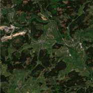
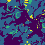
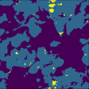
  • Various AI-based models for tree species detection are currently being trained and evaluated. In the future, this should make it possible to segment the different forest areas displayed using satellite images. The training and the evaluation are based on data provided to us thanks to the acquisition of HessenForst.

At the same time, we are working on further data acquisition in order to build up an additional data basis. Furthermore, we are currently expanding our infrastructure so that better monitoring/logging of the training process is possible.

The RGB image is a section of a larger Sentinel 2 image, retrieved from Copernicus: Open Access Hub available at https://scihub.copernicus.eu/
Ground Truth data from North Rhine-Westphalia: Waldinfo.NRW 2.26.0, available at https://www.waldinfo.nrw.de/waldinfo2/?lang=en
Projection
 

Bioeconomics and infrastructure

We help organizations in the private and public sectors to make infrastructure more technologically advanced, socially inclusive and eco-friendly. We develop solutions that address all aspects of urban living.

We leverage our core competency, visual computing, to empower our clients with technological and methodological tools that enable us all to better resolve our global challenges: climate change, health risks, energy security, and sustainable land use.